Seals, sea lions, satellites help map ocean
|
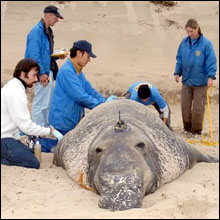
Seals, sea lions, sharks, and other marine predators are taking part in
a unique project to create a detailed three-dimensional map of the
ocean. Using satellite tags traditionally harnessed for animal
tracking, scientists at NASA's Jet Propulsion Laboratory (JPL) and the
University of California, Santa Cruz (UCSC), have outfitted their
marine recruits to collect and transmit data such as water temperature
and density.
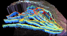
The information can then be used to create detailed 3-D models, such as the accompanying temperature profile of the North Pacific generated by seven elephant seals.
"Satellites provide a two-dimensional view of the ocean," team co-leader Yi Chao of JPL said in a NASA release. "Animals give us a slice of the ocean. They're like weather balloons in reverse."
"As we are getting more data from the sea and improving our computer models," he continued, "we should be able to make routine ocean forecasts, similar to what meteorologists have been doing in the past few decades. People who open the newspaper or turn on the TV in the morning will see the updated ocean forecast and make appropriate decisions as they plan their activities on the sea."
Team co-leader Daniel Costa, a marine biologist at UCSC, said the project will also help researchers better understand how animals interact with their ocean environments.
"Just as there are different habitats on land, the ocean has fine-scale features that are very important to animals," Costa said in the media release. "We want to be able to look at the ocean and say the equivalent of 'this is a grassland' or 'this is a forest.'"


