
Science, information management and education outreach are all happening at Ndlovu
|
Tony Swemmer, Manager of the SAEON Ndlovu Node, gave a presentation at
the 5th Kruger National Park Science Networking meeting,
which was attended by almost 200 researchers. His talk provided an
update for the research community on progress being made at the Node,
and in particular on the development of a database of all past and
current research in the savanna biome.
Nikki Stevens, the Node's GIS/database manager, is currently filling the database with data from published studies as well as metadata provided by local private game reserves and the Department of Water Affairs and Forestry. The database will eventually be accessible online, and is being designed in a way that will allow prospective researchers to search for studies or locations where specific data has, or is being collected.
Tony recently attended the SAEON planning workshop where the progress and plans for the Node were discussed. SAEON's Observation Science Specialist, Prof Tim O'Connor and Tony are currently working on ideas for long-term data collection and analysis projects for the Node.
Climate change data
Nikki attended a research symposium at the Hluhluwe-iMfolozi Park (KwaZulu-Natal), where she was previously based, as well as a workshop on high-resolution climate change data for southern Africa. The workshop, hosted by the Climate Systems Analysis Group, gave the results and data from the group's efforts to "down-scale" predictions from global climate change models.
Land cover classification
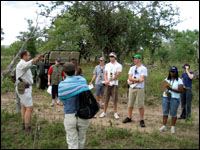
In April, the Node arranged for Dr Emma Archer and a group of honours students from the University of the Witwatersrand to access Thornybush Game Reserve, a private nature reserve in the Timbavati area. Dr Archer teaches a GIS honours module, and brings her students to the lowveld every year to find areas of contrasting land-use as part of a land-cover classification exercise.
The land cover classifications produced will ultimately feed into a larger project, an updatable land cover map for the entire lowveld, planned by the Node. Maps produced by this year's excursion will also be given to Thornybush Game Reserve, to aid management of the reserve.
Related content