
Land cover and land-use change: Coastal development in the Eastern Cape
|
- By Bronwyn Palmer, Postgraduate Student, SAEON Elwandle Node
The coastal environment is a unique and dynamic system where elements from land, sea, air and people converge.
It encompasses a wide range of terrestrial and marine environments - from rivers, coastal forests, wetlands, coral reefs and sea grass beds to the open waters of estuaries, cities and farms.
Broadly speaking, it is the portion of land influenced by being near the sea and the portion of the sea influenced by being near land. This area has remarkable ecological productivity and offers a diverse range of goods and services. As a result the coastal environment has been the centre of human activity for hundreds of years, with a marked impact on and degradation of the ecological functioning of the coastal system. As a consequence, developed coastal areas are increasingly susceptible to natural hazards. Despite this some coastal areas still offer development opportunities which may promote local and regional economic development.
Given the value of the coast, pressure to develop is increasing and there is a need to improve management of the coastal environment and its resource.
In recent years, in addition to the reliance on the natural resource base of the coastal system, coastal development is being driven by the appeal of living at the coast coupled with personal wealth, an increase in coastal holiday-homes and resorts, and demand for leisure and outdoor activities associated with the coast.
These can be related to economic conditions of increased consumer spending power, increased mobility of people and more available leisure time. This development brings about changes in land cover (vegetation and human-made features on the earth’s surface) and land-use (human activities and impacts on land cover), in response to human needs and wants. Changes in land use result in significant economic and environmental impacts within the coastal system.
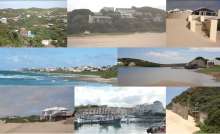
Historically, within South Africa, coastal developments were concentrated in KwaZulu-Natal and the Western Cape. These areas have in recent years become intensively developed and the market has shifted to other favourable areas, notably the Eastern Cape. The Eastern Cape coast, though developed in and around the two primary economic nodes, East London and Port Elizabeth, has until recently remained relatively undeveloped.
Development brings with it associated political and socio-economic pressures which need to be assessed and considered holistically in terms of management and planning for development within the coastal environment. With this in mind, this study aims to capture historical and current land cover for a section of the Eastern Cape coast and relate this to land-use activities. Secondly the study considers the factors that result in the observed land-use and land cover patterns.
Mapping historic and current land cover and land-use patterns
This study uses GIS (Geographic Information Systems) as the primary tool for mapping historic and current land cover and land-use patterns within the study area. GIS is an essential tool in time series analysis, enabling the efficient capture, analysis and comparison of land-use and land cover at different time intervals.
Land cover data was captured from aerial photographs at three dates: 1940, 1970 and 2004 based on availability of aerial photographs for the study area.
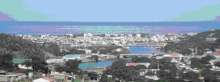
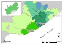
The study considers coastal land cover and land-use change within the local municipalities of Ndlambe and Ngqushwa (Figure 1). The two municipalities are similar in terms of size and environmental characteristics. This study, which is now in its second year, has identified distinct differences between the two municipalities in terms of land cover and land-use. These differences can largely be attributed to the political history of the area.
The Ngqushwa Local Municipality falls within the former Ciskei homeland area which was an “independent” black state created by the apartheid government for the resettlement of ‘black’ people relocated from ‘white’ areas. This area was re-incorporated into South Africa when the apartheid system was abolished in 1994, but a large proportion of the municipality is still considered to be tribal land and the area remains relatively undeveloped with poor infrastructure and limited urban development. In contrast, the Ndlambe Local Municipality has always been part of the Republic of South Africa and as such was subject to different policies.
Coastal development pressure
To date this study has shown that both municipalities have a high proportion of natural land cover. This status is changing as coastal development pressure increases. Development within the Ndlambe Municipality is being driven largely by economic activity and social desirability. On the other hand, there appears to be a lack of development within Ngqushwa Municipality. This is largely as a result of historical planning associated with former homeland areas and apartheid policies.
A large portion of the land in the Ngqushwa area is still registered in the name of the state and therefore still owned by the state. This discourages developers from investing in this area. It is anticipated that as demand for land within the coastal environment increases and availability of such land decreases, pressure for land within the coastal environment will shift to areas such as Ngqushwa.
Development within the study area (predominantly Ndlambe) is seen to be following two distinct development trends, namely an increase in game farming and an increase in urban type development. Stock farming is being replaced by game farming, largely due to economic factors. These include factors such as low cattle prices in comparison to income from game farming, the labour intensive factor of stock farming and more recently the effects of stock theft on stock farming.
In terms of urban type developments, people’s increasing ‘need’ to be at the coast has created demand for coastal accommodation. This has resulted in an increase in coastal development and spending on development within this zone.
Informed decision making
In order for development within the coastal zone to move forward in an environmentally and socially acceptable manner, the area needs to be managed effectively through informed decision making. GIS has facilitated the mapping of historical and current land cover from which information can be derived, which provides valuable input to the decision making process.
The study area provides a unique opportunity to learn from the mistakes of other coastal areas, such as KwaZulu-Natal and the Western Cape, and to design and implement policy that will ensure a sustainable path for development that minimizes negative impacts in the coastal zone of this section of coastline.
Data captured and information derived from this study should be used for future planning and management of coastal development within the study area.
This study is undertaken as an MSc (Master of Science) study through the SAEON (South African Environmental Observation Network) Elwandle Node and Rhodes University.
References
Adams, M., Cousins, B. and Manona, S. 1999: Uncertainty about land ownership has discouraged both public and private sector investment in the former homeland areas. Working Paper. Overseas Development Institute, Portland House, London.
Carter, R.W., 1999: Coastal Environments. An Introduction to the Physical, Ecological and Cultural Systems of Coastlines. Academic Press, San Diego, USA.
Integrated Global Observing Strategy (IGOS), 2006: A Coastal Theme Report for the IGOS Partnership. UNESCO, France.
DEAT, 2006: The National Environment Management Act: Integrated Coastal Management Bill. Department of Environment and Tourism, Pretoria.
Verburg, P.N., Schot, P., Dijst, M. and Veldklemp, A. (2004). Land use change modelling: current practice and research priorities. GeoJournal Vol. 61(309 – 324).
Visser, G. (2003). Visible, Yet Unknown: Reflections on Second-Home Development in South Africa. Urban Forum, Vol. 14, No. 4, (379-407).