
Did YOU learn about hydrological models and automated weather stations at school?
|


SAEON’s Fynbos Node recently participated in two events aimed at inspiring bright young minds with ideas around environmental science.
The first was the Biodiversity Career Day presented annually by the South African National Biodiversity Institute (SANBI), in which grade 10-12 learners from fourteen schools participated.
The second was an environmental science class on weather and climate for grade 4-7 learners at The Vine School in Lansdowne. Their fourth grade teacher, Elvirena Coetzee, previously an administrator at the SAEON Fynbos Node, was keen to collaborate with her former colleagues for the benefit of her learners.
|
Biodiversity Career Day
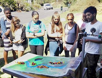
The Fynbos team has used a fully equipped automated weather station before to stimulate engagement and discussion at school events, with great success. This time the team pulled out all stops to make their presentation even more memorable and interactive – they built a hydrological/landform model with rainfall simulator to illustrate certain concepts that can seem a bit abstract when learning about them in PowerPoint.
Team members Abri de Buys, Glenn Moncrieff and Ebrahiem Abrahams used SANBI’s Biodiversity Career Day to discuss the importance of catchments, the hydrological cycle and climate change; to describe the roles of the different people involved; and to give learners an idea of potential career paths in environmental science. The team emphasised that these fields could be approached from a multitude of directions and range of qualifications due to the diverse skill sets required.
The landform/hydrological model proved a great success (apart from a leak or two!) and captured the learners’ attention. The 3-D hydrological model demonstrated the physical components used in mathematical modelling of catchments and bridged the gaps between science and education as well as theory, modelling and reality. Water fell as “rain” on the model, moved along certain flow paths and was absorbed by wetlands and vegetated areas along its pathway.
Hydrological models are theoretically complex, require advanced mathematics and consideration must be given to numerous factors in order to accurately simulate the hydrological cycle (more on this later). This can make it difficult for a learner to grasp during a lecture about catchment dynamics.
The Fynbos team transformed a conceptual understanding of the hydrological cycle into a small-scale catchment to demonstrate the water cycle and the processes that occur within a catchment, making it easier for learners to visualise and comprehend. “After all, our guiding principle was that the theory and model should all be connected,” says Ebrahiem.
“Applying our understanding of the hydrological cycle in a creative way seemed to focus the learners on thinking about water supply, storage and transfer processes. Watching water flow down the mini catchment allowed learners and the SAEON team to discuss their understanding of the hydrological cycle, the processes that are taking place and the factors that influence the movement of water across the catchment.”
Apart from some learners wanting to know upfront how much a botanist or hydrologist earns, they were intrigued by the complexity of water movement through the catchment at this scale, understanding what this meant when observing the real system and thus the difficulty in quantifying water resources.
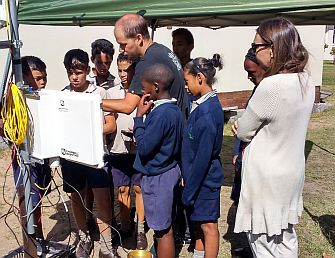
The Vine School outreach day
Although the physical landform model was excluded from The Vine School outreach day, the weather station still succeeded in capturing the attention of the grade 4 to 7 learners, having us answer question after question. The focus of this day was on how weather and climate change affect catchments and what this means for our water supply.
“We explained what the different sensors on the weather station measure and what this tells us about what’s happening in a catchment,” explains Abri. “We also discussed some of the more technical features of the station with learners that were interested in technology in general.”
When discussing the fog collector, the learners were asked to identify any problems they could think of regarding the design of the fog collector. Answers like “wind could blow the rain or fog away” and that the “rain and fog could be mixed together” showed that they were applying their minds to the issues discussed.
“The learners’ level of understanding and their eagerness to interact with us to share how they define and view climate change was impressive,” says Ebrahiem. “In particular, the lower grades were able to explain to us what climate change is, as well as some of the main contributing factors toward this change and the consequences for the environment and ecosystems.”
Overall positive feedback was received from both events, together with an invitation to participate in the next SANBI Career Day in 2017. “But the main reward was interacting with the learners and being able to share our knowledge and experience by answering questions they were interested in,” says Abri.
|