
A new long-term research site for SAEON - the Letaba Hydrological Observatory
|
By Tercia Strydom, SANParks Junior Scientist and Dr Tony Swemmer, Manager, SAEON Ndlovu Node
Over-allocation of freshwater resources and diminishing flows of most of South Africa’s rivers is hardly news. Almost every month, scientists and journalists alert the public to these problems, and their implications for economic development and the conservation of biodiversity in South Africa.
Increased demand, resulting from economic development and greater use of water by households, agriculture and industry is clearly a major part of the problem. But what about the supply side of the equation?
Supply is often assumed to be fixed in the long term, notwithstanding fluctuations from year to year caused by ups and downs in rainfall. Global climate change could alter supply significantly in the near future, but there is not much we can do about that. However, the use and management of land in the catchments of rivers can have a major effect on river flow and the supply of fresh water.
Long-term, catchment scale research has demonstrated this at sites around the world, with many of the key experiments conducted in South Africa. Most of this research has investigated the effect of land use/management on the river flow in source areas, i.e. high-altitude areas where rainfall greatly exceeds evapotranspiration, and water runs off the landscape and into rivers.
But many rivers actually lose water along their course, as they flow down into more arid areas. What is the effect of land use and management in these areas? Could appropriate land management lead to a reduction in water loss from large rivers, and significantly improve the supply of fresh water downstream?
|
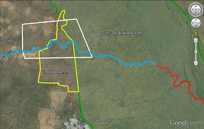
These questions form the basis of one of the first projects being implemented at a new long-term research site which the SAEON Ndlovu Node is establishing along the Letaba River, just north of Phalaborwa in Limpopo Province. The Letaba River is one of just five perennial rivers that flow through the Lowveld region of South Africa. It rises in a small area of high rainfall catchments in the Drakensberg Escarpment, before flowing east through one of the largest citrus-growing areas in the country, and then on to the Kruger National Park.
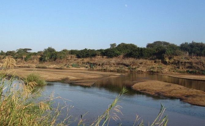
What happens when a river runs dry?
Once a majestic perennial river, the Letaba is now reduced to a trickle by the end of each winter, due to the many dams built in its catchment. Much of the water that would have flowed into the Kruger National Park, and on to Mozambique, is pumped out for domestic and agricultural use, with some even pumped all the way to Polokwane.
As a result, the river runs dry within the Kruger National Park by the end of winter in most years (Figure 1). Planned developments in the region, including the construction of a new dam next year and increased transfers of water to Polokwane, will place additional stress on the river.
While water is released from the dams upstream in order to meet the “Environmental Flow Requirements” of the river, much of it never reaches the Kruger National Park. We are hoping to work out exactly why. Critical questions are how much water seeps out of the river into the surrounding landscape, and does land use in the areas immediately adjacent to the river affect these losses?
|
The SAEON Ndlovu Node, in collaboration with South African National Parks (SANParks), the Department of Water and Sanitation (DWS), GCS Consulting, the University of KwaZulu-Natal (UKZN) and the Water Research Commission (WRC) initiated a three-year research project along the Letaba River, to compare key hydrological processes linked to river flow. This will be done in a protected area (the Letaba Ranch Nature Reserve) and a rural area just upstream of the Kruger National Park.
The Letaba River is a model river where strategic adaptive management (SAM) is currently being implemented to ensure adaptive and sustainable water resource management. This unique approach is facilitated by the institutional interaction between dam operators (from the upstream Tzaneen Dam) and downstream stakeholders including Kruger National Park. The project will contribute significantly to this management strategy by using a precise hydrological approach which will aid in improving estimates of water supply in the Letaba River.
Probing the interactive effects of land use and climate
The three-year project will form the basis of long-term data collection and research at this site, giving rise to a genuine hydrological observatory. SAEON intends to maintain all the instrumentation deployed and continue with data collection well beyond the initial three years, and add new projects, instruments and data in the future. This will allow for a better understanding of interactive effects of land use and climate, and provide the type of long-term data needed to detect, and predict, the impacts of climatic change on freshwater resources.
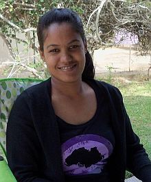
As with any research project, capacity building and academic development is pivotal. Two PhD students will be involved in the initial project, one of whom is Tercia Strydom. Tercia completed her undergraduate and Honours degrees at the University of the Western Cape before joining SANParks in 2011 as a Junior Scientist (the Junior Scientist programme is a capacity-development programme of SANParks, funded by the Andrew Mellon Foundation).
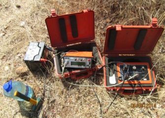
While on the programme, Tercia completed her MSc in Hydrology at the University of KwaZulu-Natal. Her PhD will focus on groundwater-surface water interaction, with the aim of determining natural streamflow losses (groundwater recharge) and gains (groundwater discharge) along the Letaba River. She has recently begun collecting data for this purpose.
A second PhD position will be advertised soon. This position will focus on direct measurement of evapotranspiration over the river and riparian zone, and scaling these up using remote-sensing.
|